| News
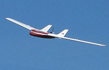
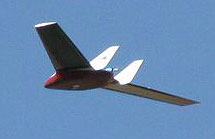
Resolution UAS Airframe Updates
– 11/05/2008
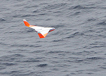
Last summer's research has resulted in some modifications to our Resolution airframe. The wing area was increased to enable more payload capacity and greater margins in the slow-speed realm of flight. Also the vertical stabilizers have been moved inboard to the wing roots. This has shown an increase in yaw stability as well as has made the fins less prone to "hangar rash" damage in the shipboard environment.
See a video of Resolution takeoff from ATI's launcher system. [see video]
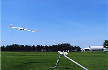
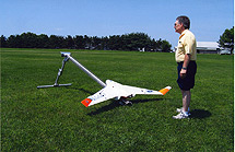
ATI UAS Summer Test Program
– 09/05/2008
The summer of 2008 has seen some additional testing and refinements of the UAS airframe and launcher system. These tests were carried out in various locations in the midwest US. Launcher photos by Daniel Terrel.
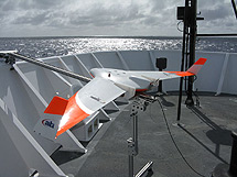
ATI Resolution UAS Takes Part in NOAA North Pacific Marine Debris Survey Research
– 04/10/2008
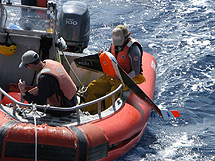
From March 24 through April 10 the unmanned aircraft system (UAS) development team from ATI took part in a marine debris survey mission to the sub-tropical convergence zone in the North Pacific.
ATI's goals were to explore actual shipboard launch and recovery procedures as well as test the system in an operational environment. Tim Veenstra, president of ATI wrote:
|
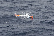
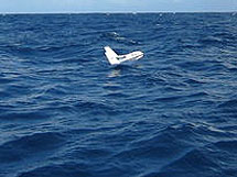
The Resolution UAS airframe performed exceptionally well. From the perspective of aircraft design, the airframe is extremely strong and has proven to be robust and durable. The carbon fiber/Kevlar wings have never suffered damage despite operating in rough seas, strong winds, shipboard storage and movement, and having the small boat come down on top of them during the recovery. The aircraft was passed off from small boat to ship and then from deck personnel to UAS personnel by grabbing on to one wing and lifting the UAS.
The new center section design on the second airframe (Malolo 2) made a number of significant improvements over the earlier version. The center section, despite being significantly larger, is more streamlined, stronger and requires less power to maintain altitude than Malolo 1. Marinization and protection of the electronics excellent. Access to batteries is through a screwed on hatch cover that allows battery changes to take place in about 1 minute. Despite being turned upside down after a landing due to swell and winds, we maintained water tight integrity. Adding additional sensors, batteries or antennas will be possible with this new design.
The feed into the Anomoly Detection Software (ADS) computer worked very well. The ADS was installed on a laptop and located on the bow. GPS feed coming from the UAS was plugged into the ADS computer. Sea state conditions were not conducive to gathering reliable automatic hits from the ADS due to foam and breaking waves. The operator monitoring the ADS computer could input hits that were visually seen on the monitor. Each “hit” saved an AVI file of the incoming video and time stamped the file with a GPS location and time.
The style or type of survey path to fly was not defined before the cruise nor could it have been without actually seeing how the different aspects of the cruise would work together. FAA limitations and the fact that at ½ mile distance, the Resolution becomes hard to see in order to take back control made trying different survey designs difficult if not impossible. After seeing on-board operations, we believe a dynamic survey path would be most conducive to debris survey as well as being flexible for varying distances required or allowed. Curt has been writing code that will allow for automatic waypoint updates for the Resolution during flight. With this new code the UAS can continue to fly between two (or more) relative points that are based on a distance and bearing from the ship. As the ship moves, the points keep changing and the UAS will end up flying a dynamic route in front of the ship from port to starboard, based a set distance from the ship. As the ship's speed changes, the route becomes either tighter or more spaced apart. We would like to have tested this method during the cruise if weather had cooperated. Instead, we will be testing this survey method on land with a moving “home” position.
The ATI team enjoyed the opportunity to work along side NOAA personnel on this cruise. Despite the reduced number of UAS flights that we were able to perform due to weather and legal restrictions, we feel that the time was beneficial for the advancement of shipboard UAS operations and further refinement of the Resolution UAS. We look forward to the opportunity of working with NOAA again and desire input from NOAA that will enable us to improve the Resolutions usefulness and functionality for specific NOAA missions.
See a hi-rez video of Resolution making a water landing in the North Pacific. -[see video] |
Media Attention Paid to NOAA's Unmanned Aerial System Project
– 12/14/2007
from Marine Debris Weekly
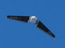
On December 13th, staff with the Papahanaumokuakea Marine National Monument and the NOAA Pacific Islands Fisheries Science Center’s Coral Reef Ecosystem Division joined Airborne Technologies to display the capabilities of their new unmanned aerial system (UAS), the Malolo I ("flying fish"). [read more]
National Oceanic Atmospheric Administration's New Eye in the Sky
– 12/14/2007
By Stephanie Lum for KHNL
SCHOFIELD BARRACKS (KHNL) -- Cleaning the ocean of debris is a dirty job the National Oceanic and Atmospheric Administration (NOAA) has been doing for years.
A new tool will help in its mission at sea.
It's called the "Malolo One," a battery-operated, remote-controlled plane, seven feet wide, and weighing a light ten pounds. [read more/see video]
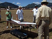
ATI demos UAS sea legs
– 12/12/2007
ATI demonstrated Resolution UAS to NOAA NESDIS off the north shore of the Hawaiian island of Oahu and at Schofield Barracks, December 11 through 13. Among the capabilities shown were sea-borne logistics, launch and recovery procedures, data transmission and autonomous flight. The system is scheduled to be part of a NOAA marine debris detection mission in March of 2008. Click on the following link to view a slide show of the demo. [view slide show]
Unmanned Flights to Enhance Marine Debris Surveys
– NOAA Coral Reef News, Vol. 5, No. 1, October 2007 Issue, page 3
A series of successful test flights of a prototype Unmanned Aircraft System (UAS) were recently conducted in the restricted airspace maintained by the U.S. Army at Schofield Barracks range facility in Hawai`i. The Resolution UAS from Airborne Technologies Inc. that is being developed for NOAA’s Pacific Islands Fisheries Science Center (PIFSC)...
[read more]
Search for sea debris will be on autopilot
– 09/18/2007
By Diana Leone for the Honolulu Star-Bulletin
An unmanned aircraft with a 7-foot wingspan will be dispatched to the Northwestern Hawaiian Islands in the fall or spring to search for drifting marine debris. Alaska-based Airborne Technologies Inc. is NOAA's contractor to design and build the prototype aircraft, which is made of foam core, carbon fiber, some fiberglass and Kevlar, the tough material used in bulletproof vests. [read more]
High Seas GhostNet Detection Project
For the last several years, the NOAA Environmental Technology Laboratory, the NOAA Oceanic Research and Applications Division, the NOAA Pacific Fisheries Environmental Laboratory, and Airborne Technologies, Inc. have been developing a technique to efficiently locate ghostnets in the open ocean… [read more]
Alaska firm goes high-tech hunting for lost fishing nets
– 06/05/2005
By Bob Tkacz
For the Alaska Journal
An Alaska technology company is working with a federal agency in an effort to remove an environmentally dangerous and costly problem from the Pacific Ocean: abandoned or lost fishing nets, known as ghostnets.
Using satellite monitors that track marker buoys attached to ghost fishing nets, Wasilla-based Airborne Technologies Inc. and the National Oceanic and Atmospheric Administration are working to find these ghostnets so they can be properly disposed. [read more]
Scientist goes fishing for deadly nets in sea
— 02/22/2005
...Abandoned fishing nets drift through the world's oceans like ghosts, trapping sea turtles and snagging birds that dip down for a quick meal...Finding the nets at sea is just the first step, said Tim Veenstra, president of Airborne Technologies (& Ocean Trek Research) in Wasilla, Alaska, who helps direct the NOAA ghostnet project...Veenstra's company is pioneering an effort to create 25-pound, solar-powered buoys that could transmit location by satellite. [read more]
|
|